13.40 g/t Gold over 0.5 meters in Croesus Vein Extension & 14.00 g/t Gold over 0.6 meters in New Parallel Vein
Vancouver, BC – March 30, 2022 – HighGold Mining Inc. (TSX-V:HIGH, OTCQX:HGGOF) (“HighGold” or the “Company”) is pleased to report assay results for the first seven (7) holes from the 2022 Winter Drill Program (the “Program”) at its Munro-Croesus project (the “Project”) located in the Timmins Gold Camp, Ontario, Canada (Figure 1). The planned 8,000-meter Program is the largest to date on the Project and continues to test targets proximal and distal to the past producing Croesus Mine, along with a variety of new targets on the greater consolidated land position.
New drilling has successfully intersected the equivalent of the historic high-grade Croesus Vein in hole MC22-96, positioned 100 meters to the northeast of the former Croesus Mine underground workings, and has also discovered a new parallel quartz vein, 370 meters to the northwest, in the prospective Croesus Flow. Assay highlights are discussed below and shown in Figure 2 and Table 1.
Highlight Drill Hole Results
- 13.40 g/t Au over 0.5m within a broader 4.80m interval grading 3.60 g/t Au (hole MC22-96) from an intersection of the Croesus Vein 100m northeast of the Croesus Mine
- 14.00 g/t Au over 0.6m within a broader 2.60m interval grading 3.42 g/t Au (hole MC22-92) from a new vein zone intersected 370m northwest of the Croesus Mine
“We are very encouraged by these new results, which have intersected the interpreted northeastern extension of the historic high-grade Croesus Vein and have also identified a prospective parallel quartz vein system to the northwest,” commented President and CEO Darwin Green. “These discoveries are a ‘proof of concept’ breakthrough of our current geological and structural models, which highlight the potential for the Croesus Vein system to continue to the northeast along a major regional structure and also, as demonstrated in hole 92, that the prospective Croesus Flow could host multiple analogues to the Croesus Vein as we target this favourable host along strike. Step One was successful confirmation that key gold-bearing vein structures extend outside the immediate area of the historic Croesus Mine. Step Two will be systematic follow-up drilling, expanding the extent of these new intersections, and testing for the type of exceptionally high-grade gold mineralization that differentiated the Croesus Mine.”
The Munro-Croesus Project
The Munro-Croesus Project is located along Highway 101 in the heart of the Abitibi greenstone belt, Canada's premier gold mining jurisdiction (Figure 1). The Project covers 51 km2 (20 mi2) of highly prospective geology situated between the Black Fox Mine Complex operated by McEwen Mining Inc. and the Fenn-Gib gold deposit being developed by Mayfair Gold Corp. and lies proximal to major gold-bearing breaks. Extensive land consolidation by the Company in 2020-2021 has now unified the patchwork of patented and unpatented mining claims surrounding the Croesus Gold Mine into one coherent package and has enhanced the exploration potential of the Project.
The former Croesus Gold Mine is renowned for having produced some of the highest-grade gold mined in Ontario. Total historical Croesus mine gold production from milled ore as reported by the Ontario Department of Mines (Reference- ODM Vol. LX, Part VIII, 1951) was 14,854 ounces gold from 5,333 short tons milled for an average grade of 2.78 oz gold per short ton (95.3 g/tonne). Research by a previous owner suggests that the above-reported milled ore production did not include the very high-grade gold ore which was shipped directly to the Canadian Mint for processing. Five (5) gold samples purchased by the Ontario Bureau of Mines for exhibition purposes and now in possession of the Royal Ontario Museum in Toronto, Ontario weigh 85 pounds collectively and contain 480.7 ounces of gold or 11,310 oz gold per short ton (387,727 g/tonne).
Discussion of Results
Croesus Vein Northeast Extension and Down-Dip Targets
A portion of the 2022 Winter Drill program was designed to test for the possible strike extension of the historic Croesus Vein to the northeast of the underground workings in an area of no previous drilling. Recent structural geology studies completed by SRK Consulting identified a dominant NE-SW trending “D2” structure passing through the Croesus Shaft area and highlighted the importance of these D2 structures as potential hosts for gold mineralization, with particular attention given to areas where these structures cross-cut mafic variolitic flows and graphitic interflow sedimentary rocks. Three (3) holes (MC22-94 to MC22-96) were designed to test this D2 feature north of the mine, with a fourth hole (MC22-97) testing at depth below the historic mine workings.
Hole MC22-96, located approximately 100 meters from the Croesus mined-out stopes and drilled at -65 degree dip, yielded 3.60 g/t Au over 4.80 meters, including 13.40 g/t Au over 0.5 meters. The mineralization in hole MC22-96 is characterized by 20-30% quartz veining with 2-5% arsenopyrite within a quartz-sericite-pyrite altered basalt. Narrow pyrite-pyrrhotite-bearing graphitic interflow sediments were observed downhole of the gold intercept and returned encouraging base metal values with 2.89% Zn, 1.03% Pb and 13.09 g/t Ag over 2.1 meters. Both these intercepts remain open at depth and along strike to the northeast.
Hole MC22-95, drilled at a shallower -45-degree dip from the same pad as hole MC22-96, intersected the same structure but returned only anomalous gold values (1.28 g/t Au over 1.16 meters).
Hole MC22-94, drilled immediately northeast of the underground workings (100m southwest of holes 96 and 96) returned no significant values, with faulting inferred to have offset the Croesus Vein.
Hole MC22-97 was a deeper test below the underground workings and returned only anomalous gold values (1.16 g/t Au over 0.50 meters and 1.70 g/t Au over 0.60 meters).
Northwest Croesus Flow Target
The historic Croesus Vein is developed within the upper sulphidic pillow breccia phase of the Croesus Flow (basalt). The Company has targeted this prospective Croesus Flow along strike to the southeast and northwest of the Croesus Mine to identify areas where this flow is cross-cut for by modeled D2 structures and thus has the potential for a repetition of ‘Croesus-style’ veining and mineralization.
Hole MC22-92 returned 3.42 g/t Au over 2.60 meters, including 14.0 g/t Au over 0.6 meters within veined and quartz-sericite-pyrite-altered pillowed Croesus Flow. This intersection is located approximately 370 meters northwest of the Croesus shaft and may represent a new northern extension of the historic Brown-Munro vein, located 365 meters to the southwest. The inclined #1 Shaft was sunk at the northern end of the Brown-Munro vein circa 1908 to a depth of 318 feet and the Brown-Munro vein reportedly contained visible gold where intersected by drilling at the 300-foot level (Reference - The Northern Miner, August 14, 1918).
Holes MC22-91 and MC22-93 were drilled to the west of the Croesus shaft and returned only anomalous values (1.29 g/t Au over 0.50 meters and 0.62 g/t Au over 1.0 meters in hole MC22-93).
Drill hole locations for the seven (7) holes reported herein are shown in Figure 2 with Significant Assay Results summarized in Table 1.
Current 2022 Winter Drill Program
The 2022 Winter Drill Program, currently in progress, is a continuation of the late 2021 Fall Drill Program. The 8,000-meter Winter Program includes one drill rig and is expected to run until mid-April. The Program will test established targets near the past-producing Croesus Gold Mine, as well as first-pass drilling at several new priority targets generated on the greater Project.
About HighGold’s Timmins Properties
HighGold owns 100% of each of its three Timmins properties. The Munro-Croesus Gold Project is located approximately 75 kilometers (47 miles) east of Timmins, proximal to the Porcupine-Destor and Pipestone Faults, and approximately two kilometers (1.2 miles) northwest and along trend of Mayfair Gold Corp.’s multi-million ounce Fenn-Gib gold deposit. Mining occurred intermittently at Munro-Croesus between 1915 and 1936. The Golden Mile 86 square kilometer (34 square mile) property is located nine kilometers (5.6 miles) northeast of Newmont’s multi-million-ounce Hoyle Pond deposit in Timmins. The Golden Perimeter 118 square kilometers (46 square mile) property is located to the south and southeast of Timmins on the south edge of the Shaw dome structure.
About HighGold
HighGold is a well-funded mineral exploration company focused on high-grade gold projects located in North America. HighGold’s flagship asset is the high-grade Johnson Tract Gold (Zn-Cu) Project located in Southcentral Alaska, USA. The Company also controls a portfolio of quality gold projects in the greater Timmins gold camp, Ontario, Canada that includes the Munro-Croesus Gold property, which is renowned for its high-grade mineralization, and the large Golden Mile and Golden Perimeter properties. HighGold’s experienced Board and senior management team, are committed to creating shareholder value through the discovery process, careful allocation of capital, and environmentally/socially responsible mineral exploration.
Qualified Person and Quality Assurance
Ian Cunningham-Dunlop, P.Eng., VP Exploration for HighGold Mining Inc. and a qualified person (“QP”) as defined by Canadian National Instrument 43-101, has reviewed and approved the technical information contained in this release.
On Behalf of HighGold Mining Inc.
“Darwin Green”
President & CEO
For further information, please visit the HighGold Mining Inc. website at www.highgoldmining.com, or contact:
Darwin Green, President & CEO or Naomi Nemeth, VP Investor Relations
Phone: 1-604-629-1165 or North American toll-free 1-855-629-1165
Email: moc.gninimdloghgih@noitamrofni.
Website: www.highgoldmining.com
Twitter: @HighgoldMining
Additional notes:
Starting azimuth and dip (Azimuth/-Dip) for drill holes reported today are noted as follows: MC22-91 (300/45), MC22-92 (300/45), MC22-93 (270/45), MC22-94 (310/45), MC22-95 (310/45), MC22-96 (310/65), and MC22-97 (276/56). Drill hole lengths range from a minimum of 111m to a maximum of 318m.
Samples of drill core were cut by a diamond blade rock saw, with half of the cut core placed in individual sealed polyurethane bags and half placed back in the original core box for permanent storage. Sample lengths typically vary from a minimum 0.2-meter interval to a maximum 1.5-meter interval, with an average 0.5 to 1.0-meter sample length. Drill core samples were delivered by truck in sealed woven plastic bags to ALS Geochemistry laboratory facility in Timmins, Ontario for sample preparation with final analysis at ALS Geochemistry Analytical Lab facility in North Vancouver, BC. ALS Geochemistry operate meeting all requirements of International Standards ISO/IEC 17025:2017 and ISO 9001:2015.
Gold is determined by fire-assay fusion of a 50 g sub-sample with atomic absorption spectroscopy (AAS). Samples that return values >10 ppm gold from fire assay and AAS are determined by using fire assay and a gravimetric finish. Various metals including silver, gold, copper, lead and zinc are analyzed by inductively-coupled plasma (ICP) atomic emission spectroscopy, following multi-acid digestion. The elements copper, lead and zinc are determined by ore grade assay for samples that returned values >10,000 ppm by ICP analysis. Silver is determined by ore grade assay for samples that returned >100 ppm.
The Company has a robust QAQC program that includes the insertion of blanks, standards and duplicates.
Readers are cautioned that the Company has no interest in or right to acquire any interest in any of the neighboring mines or deposits, and that mineral deposits, and the results of any mining thereof, on adjacent or similar properties are not indicative of mineral deposits on the Company's properties or any potential exploitation thereof.
Neither TSX Venture Exchange nor its Regulation Services Provider (as that term is defined in the policies of the TSX Venture Exchange) accepts responsibility for the adequacy or accuracy of this release.
Forward looking statements: This news release includes certain “forward-looking information” within the meaning of Canadian securities legislation and "forward-looking statements" within the meaning of the United States Private Securities Litigation Reform Act of 1995 (collectively “forward looking statements”). Forward-looking statements include predictions, projections and forecasts and are often, but not always, identified by the use of words such as “seek”, “anticipate”, “believe”, “plan”, “estimate”, “forecast”, “expect”, “potential”, “project”, “target”, “schedule”, “budget” and “intend” and statements that an event or result “may”, “will”, “should”, “could” or “might” occur or be achieved and other similar expressions and includes the negatives thereof. All statements other than statements of historical fact included in this release, including, without limitation, statements regarding the Company’s currently ongoing drill program and pending assays are forward-looking statements that involve various risks and uncertainties. There can be no assurance that such statements will prove to be accurate and actual results and future events could differ materially from those anticipated in such statements. Forward-looking statements are based on a number of material factors and assumptions. Important factors that could cause actual results to differ materially from Company’s expectations include actual exploration results, changes in project parameters as plans continue to be refined, results of future resource estimates, future metal prices, availability of capital and financing on acceptable terms, general economic, market or business conditions, uninsured risks, regulatory changes, defects in title, availability of personnel, materials and equipment on a timely basis, accidents or equipment breakdowns, delays in receiving government approvals, unanticipated environmental impacts on operations and costs to remedy same, and other exploration or other risks detailed herein and from time to time in the filings made by the Company with securities regulators. Although the Company has attempted to identify important factors that could cause actual actions, events or results to differ from those described in forward-looking statements, there may be other factors that cause such actions, events or results to differ materially from those anticipated. There can be no assurance that forward-looking statements will prove to be accurate and accordingly readers are cautioned not to place undue reliance on forward-looking statements.
Figure 1 – Location of HighGold Projects in Timmins Gold Camp, Ontario
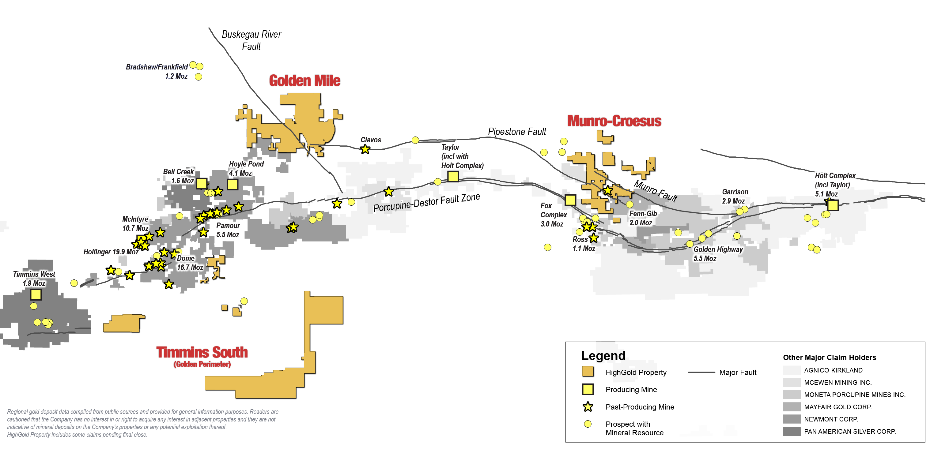
Figure 2 – Munro-Croesus Project – 2022 Drill Hole Location Map

Table 1 – Munro-Croesus Project – New Drill Results
| Drill Hole |
From |
To |
Length* |
Au |
Ag |
Pb |
Zn |
|---|---|---|---|---|---|---|---|
|
Northwest Croesus Flow |
|||||||
|
MC22-91 |
No Significant Values |
|
|
|
|||
|
MC22-92 |
92.90 |
95.50 |
2.60 |
3.42 |
|
|
|
|
Incl. |
92.90 |
93.50 |
0.60 |
14.00 |
|
|
|
|
Basket Target (West of Walsh vein) |
|||||||
|
MC22-93 |
109.00 |
109.50 |
0.50 |
1.29 |
|
|
|
|
And |
152.00 |
153.00 |
1.00 |
0.62 |
|
|
|
|
Croesus Vein Extensions |
|||||||
|
MC22-94 |
No Significant Values |
|
|
|
|||
|
MC22-95 |
39.40 |
42.40 |
3.00 |
0.51 |
|
|
|
|
Incl. |
39.40 |
40.50 |
1.10 |
1.16 |
|
|
|
|
MC22-96 |
28.70 |
33.50 |
4.80 |
3.60 |
|
|
|
|
Incl. |
30.50 |
33.00 |
2.50 |
4.78 |
|
|
|
|
Incl. |
31.00 |
31.50 |
0.50 |
13.40 |
|
|
|
|
And |
83.90 |
86.00 |
2.10 |
0.05 |
13.1 |
1.03 |
2.89 |
|
MC22-97 |
34.00 |
34.50 |
0.50 |
1.16 |
|
|
|
|
And |
38.50 |
39.10 |
0.60 |
1.70 |
|
|
|
|
Note - Drill intercepts reported as core lengths are estimated to be 70‐100% true width. Averages are length weighted. Ian Cunningham-Dunlop, P.Eng., VP Exploration for HighGold Mining Inc. and a qualified person as defined by Canadian National Instrument 43-101, has reviewed and verified the information within this table |
|||||||