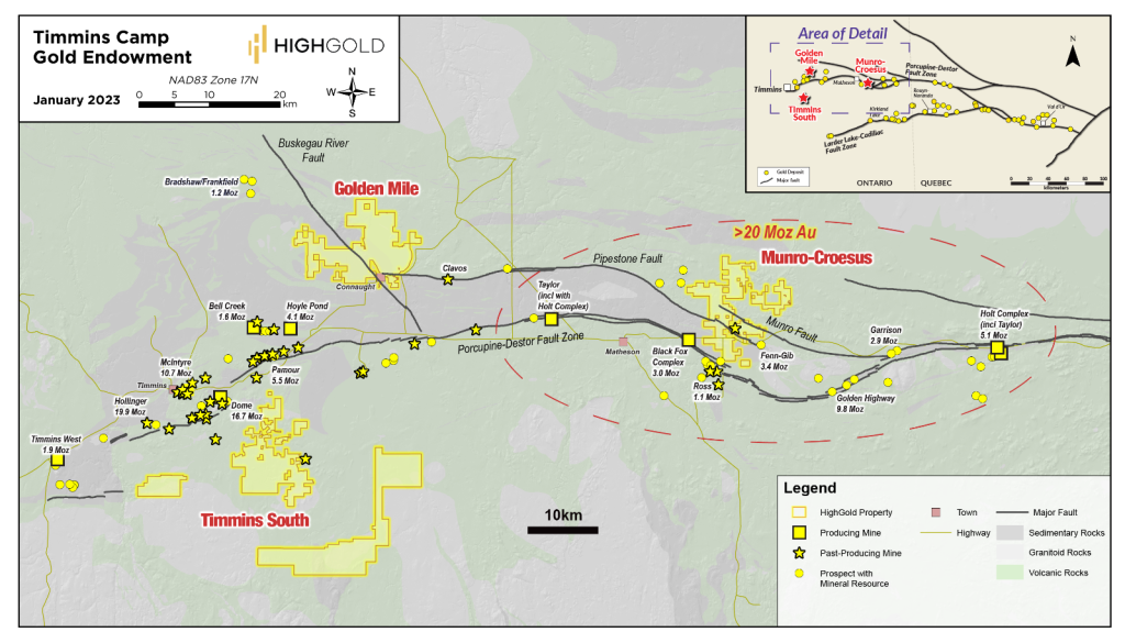
The Munro-Croesus Gold Project is located approximately 75 kilometers (47 miles) east of Timmins, Ontario along Highway 101. This large, 100% owned land package includes the past-producing Croesus Mine, which yielded some of the highest-grade gold ever mined in Ontario. The highly-prospective geology is proximal to the Porcupine-Destor Deformation Fault Zone and Pipestone Fault and located approximately three kilometers (1.9 miles) northwest and along trend of Mayfair Gold's multi-million ounce Fenn-Gib gold deposit.
Snapshot
| Location | Matheson, Ontario, Canada |
| Ownership | 100% |
| Status | Active drill programs for 2023 |
| Deposit Type | Orogenic gold |
| Property Size | 63 square kilometers (24 square miles) |
| Structural Break | Porcupine-Destor and Pipestone Faults |
| Host Rock | Ultramafic sequences and Porcupine sediment-volcanic contact with high angle, north to northeast cross structures |
| Age | Precambrian (Neoarchean) |
| Main Economic Elements | Gold |
Location Map
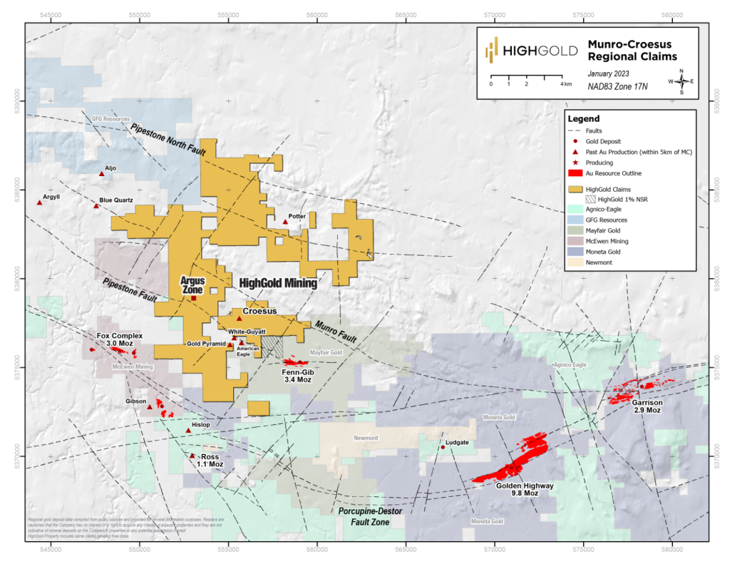
Munro-Croesus Regional Claims Map
Geological and Structural Setting
Overview
- The Project is associated with the Porcupine-Destor Fault Zone, a significant regional gold-bearing structural break, which traverses northern Ontario and Quebec and has collectively produced over 110 million ounces of gold.
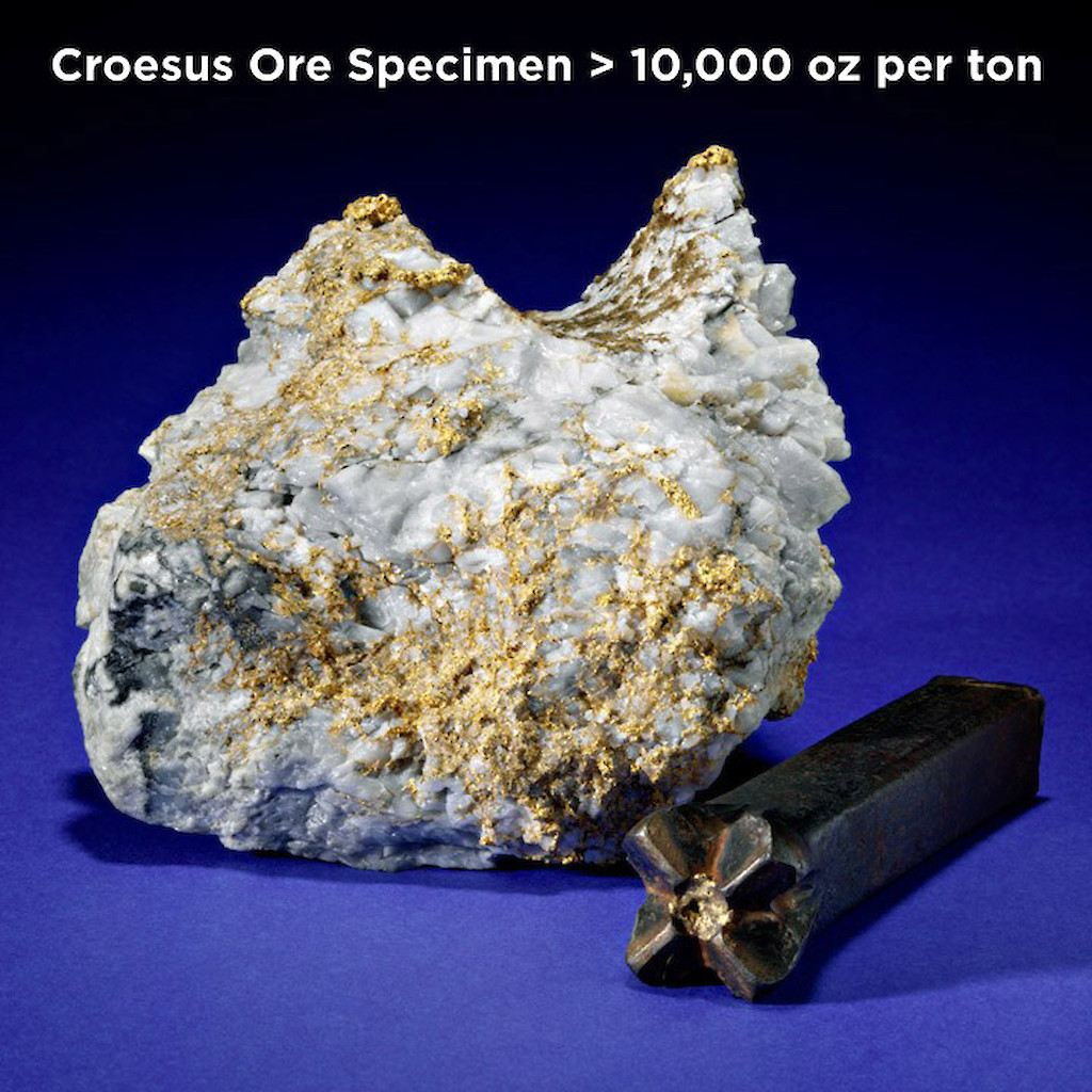
- The historic Croesus Mine, located on the project property, is famous for its bonanza grade gold production and five Croesus mine gold specimens currently held by the Royal Ontario Museum in Toronto, Canada which, collectively, weigh 85 pounds and contain 480.7 ounces of gold or 11,310 ounces gold per short ton (387,771 grams per t tonne).
- Multi-million ounce (under 1g/t gold) bulk tonnage gold deposits are also located in the immediate region of the project and include the Fenn-Gib gold project being developed by Mayfair Gold Corp. and the Tower Gold Project (Golden Highway and Garrison deposits) being developed by Moneta Gold Inc. The Black Fox underground gold mine operated by McEwen Mining is located 1.5 kilometers southwest of the project.
History
- The Munro-Croesus property was part of the property spinout of the gold assets of Constantine Metals to HighGold Mining in July 2019. In 2007, Constantine Metal Resources acquired a 100% interest, subject to a net smelter interest, in the 13 patented mining claims, two Crown mineral leases and two unpatented mining claims of the high-grade gold property, including the past-producing Croesus Mine. Prior to the acquisition of this property by Constantine, the Croesus Mine property had been in private hands since its discovery in 1914, except for brief periods when they were optioned by publicly traded companies.
- Historic production from the Croesus Mine between 1915 and 1936 was 14,859 ounces of gold mined from 5,333 short tons with an average grade of 2.78 ounces per ton gold (95.3 g/t gold). This production number did not include the ore that was mined and shipped in packing crates directly to the Royal Canadian Mint.
Geology
- The Munro-Croesus property is underlain by sedimentary rocks of the Procupine assemblage to the south, and by mafic/ultrmafic volcanic rocks of the Upper Kidd-Munro assemblage to the northeast.
- Gold mineralization across the property can be broadly characterized as structurally-controlled orogenic gold mineralization within an Archean greenstone belt setting. These types of deposits are typically hosted by quartz-carbonate veins and are located along crustal-scale fault zones in deformed geenstone terranes.
- Most of the known gold occurances on the project are associated wit an eight kilometer (five mile) northwest trending segment of the Pipestone Fault, which is a splay of the Porcupine-Destor Fault Zone, a major regional structure that extends for approximately 200 kilometers (124 miles) westward from Destor (Quebec) to Timmins (Ontario). In the region of the Project, the Porcupine-Destor Fault Zone exhibits a large-scale flexure or bend associated with two major splays, the aforementioned Pipestone Fault and Munro Fault.
Exploration
- The current programs represent the first exploration in 90 years following a major land consolidation by HighGold Mining, including more than 15 land acquisitions (a 140% increase in the land area) between 2020 and 2022.
- Ground DCIP (direct current induced polarization) and magnetic survey totaling 63 line-kilometers over core target areas and key structures was completed in 2022. In addition, data compilation, prospecting and rock/soil sampling were carried out.
- The 2022 winter drill program (7,401 meters drilled in 33 holes) included the discovery of near-surface bulk tonnage style gold mineralization at the new Argus Zone and the intersection of the new high-grade quartz veins near the historic Croesus Gold Mine.
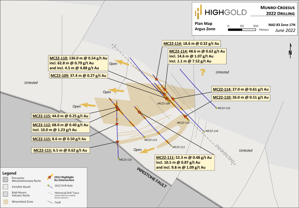
Argus Zone
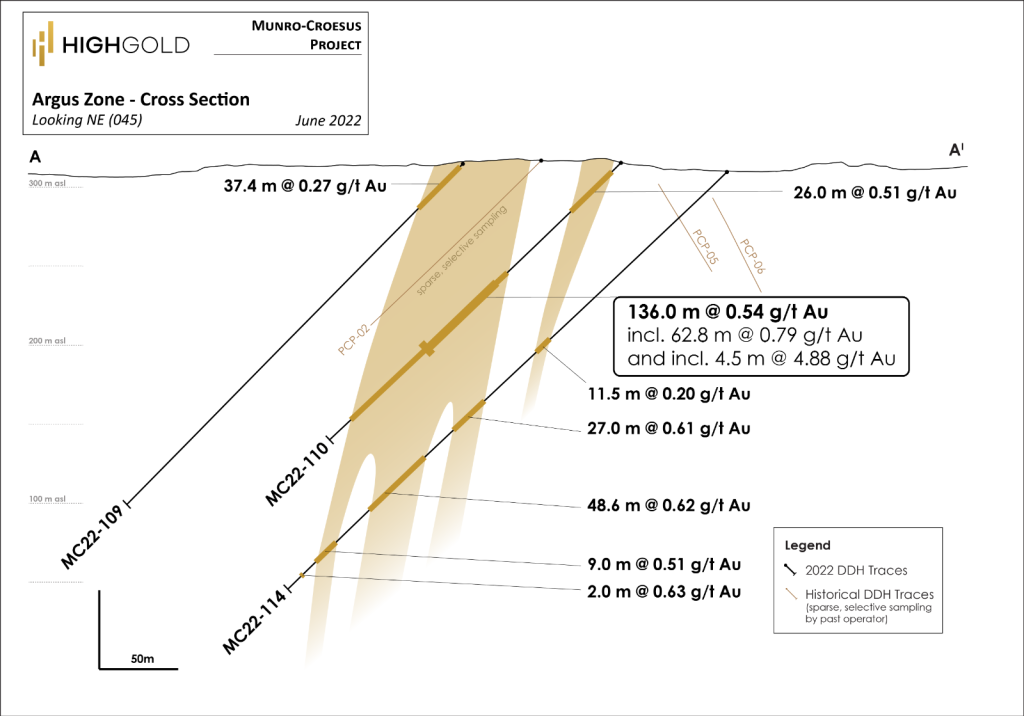
- Drill results included 0.54g/t gold over 136 meters starting at a vertical depth of 70 meters. This intersection included 62.8 meters at 0.79 g/t gold, including 4.5 meters at 4.88 g/t gold in hole MC22-110 (see HighGold press release dated May 9, 2022).
- Five of six holes drilled at the Argus Zone intersected significant intervals of gold mineralization, which are open to expansion in multiple directions, including to the west toward the intersection of the Argus Zone trend with the regional Pipestone Fault.
- The Argus Zone is characterized by silicified mafic variolitic volcanics cut by northeast-trending pyritic veinlets within a broader halo of carbonate alteration and local development of specular hematite.
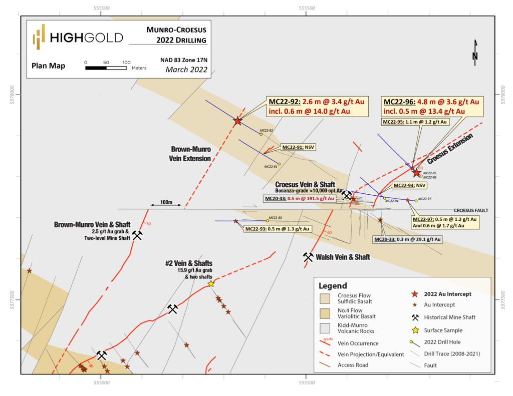
Croesus Vein Extension
- Drill results included 13.40 g/t gold over 0.5 meters within a broader 4.80 meter interval grading 3.60 g/t gold (hole Mc22-96) from an intersection of the Croesus Vein, 100 meters northeast of the historic Croesus Mine (see HighGold press release dated March 20, 2022).
- Drill results included 14.00 g/t gold over 0.6 meters within a broader 2.60 meter interval grading 3.42 g/t gold (hole Mc22-92) from a new quartz vein zone intersected 370 meter northwest of the historic Croesus Mine.
- The north-south trending, shallow east dipping historic Croesus Vein is found within the upper sulphidic pillow breccia phase of the Croesus basalt flow.
The new discoveries in 2022 are proof of concept of HighGold's geological and structural models, which highlight the potential for the Croesus Vein system to continue to the northeast along a major regional structure and that the prospective Croesus Flow could host multiple analogues to the Croesus Vein along strike.